NOTE: Due to flooding in the Gunbower State Forest and Gunbower National Park, we are utilising an alternative course for 2023.
![]()
Run alongside the emus and kangaroos on this non-technical trail run through the Gunbower State Forest. The course for the North Central CMA 12.5km Trail Run is mostly off-road and is an ideal introduction to trail running. If you’re not quite sure about running the half, this shorter course is the one for you. It’s flat and takes you along the dirt tracks of this stunning bush setting.
EVENT INFORMATION
| Distance | 12.5km |
| Pre-race briefing | 8.05am at the start line |
| Start time | 8:15am |
| Cut off time | 3 hours |
| Start line | Town Bridge, Cohuna |
| Finish line | Town Bridge, Cohuna |
| Course description | Non-technical trail |
| Age limit | 12 years or older on race day |
INCLUSIONS
- Race entry
- Race bib with timing chip
- Safety pins
- Water stations on course
- Finishers medal
COURSE DESCRIPTION
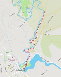
The start line is at the roundabout on Island Road, near the entrance to the Cohuna Recreation Reserve. The course runs through the Cohuna Recreation Reserve before entering the Gunbower State Forest off Mill Road. You will wind your way along the tracks beside the Gunbower Creek for 6.25km before turning around and following the same route back, emerging onto Island Road at the Second Oval gate (opposite the caravan park entrance). Island Road is bitumen and this will take you to the finish line at the town bridge.
The course is a mix of dirt vehicular bush tracks and single tracks and as such, can be uneven. If it has rained it can be wet, slippery and boggy in places. There will be the odd pothole, stick, branch and stones, and even kangaroo and emu poo, so runners should be mindful to look at the road surface as they are running, as well as enjoying the surrounds. See below for a detailed map and names of tracks.
When emerging onto Island Road, a marshal will direct you to cross to the left-hand side of Island Road. Participants still on the Island Road section of the course at 9.30am will need to stick to the very left of the road, as the cycling events begin. Please listen to and follow marshal instructions for your safety and that of other participants.
Aid stations
Aid stations are located at the 1.4km, 4.3km, 6.3km (toilet), 8.3km and 11.1km marks. Toilets are located in Apex Park (near the start line) and at the turnaround point at the picnic ground adjacent to the junction of Five Sleeper Track and Rifle Butt Track.
Course markings
We will have some marshals on course, but most of the course will be marked using pink surveyors tape hanging and tied to trees. It will be placed periodically along continuous sections of track, as well as at intersecting tracks to indicate which turn to take. Red and white tape will be placed across roads that are out of bounds. Do NOT cross any red and white tape. It is important you follow the pink tape to avoid running off-course. The 21.1km entrants utilise the same course, so you will see ribbons for both events.
Look for these course markings:
- Pink arrows
- Pink tape strung from trees
- Red and white tape across no access areas


Course directions and map
The start line is at the roundabout near the entrance to Cohuna Recreation Reserve, Island Road, Cohuna (near the town bridge).
The course follows this route:
- Enter Cohuna Recreation Reserve
- Immediately right, follow track in front of the first oval
- Follow track behind the second oval
- Through gate and behind pistol club (Gunbower State Forest)
- Left onto Mill Rd
- Through old sawmill
- Follow trail along creek
- Left onto Rifle Butt Rd
- Left onto unnamed road, hugging the creek
- Left onto Rifle Butt Track
- Immediately left onto unnamed road, hugging the creek
- Follow this track alongside the creek (parallel to Rifle Butt Track)
- Turn around at picnic ground adjacent to junction of Five Sleeper Track and Rifle Butt Track
- Retrace steps back and exit state forest through the gate into the second oval
- Exit onto Island Rd at the second oval gate (opposite caravan park entrance)
- Finish line at town bridge, Cohuna.
Thanks to North Central CMA for its generous sponsorship of this event.
![]()